Hunters-Island-2025
Quetico Hunter Island 2025
Index
- 2025-08-06 - Bottle Portage on Lac la Croix to island N of Saturday Bay Crooked Lake
- 2025-08-07 - Crooked Lake to Moose Bay on Basswood River
- 2025-08-08 - Basswood River to Canadian Point of Basswood Lake
- 2025-08-09 - Basswood Lake to small island on Carp Lake
- 2025-08-10 - Carp Lake to Ottertrack Lake near Little Knife Portage
- 2025-08-11 - Ottertrack Lake to Saganagons Lake
- 2025-08-12 - Saganagons Lake to Koko Falls portage
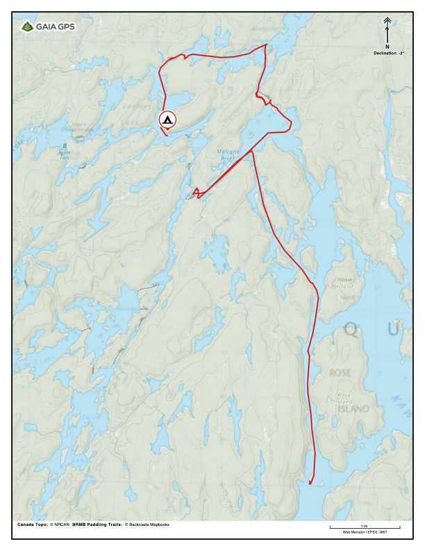
- 2025-08-13 - Koko Falls to island SW of Rose Island on Kawnipi Lake
- 2025-08-14 - Kawnipi Lake to burned island on Shelley Lake
- 2025-08-15 - Shelley Lake to downstream of Chatterton Falls on Russell Lake
- 2025-08-16 - Russell Lake to SW end of Sturgeon Lake, near exit to Maligne River
- 2025-08-17 - Maligne River to Tanner Lake E of May Island
- 2025-08-18 - Tanner Lake to Lou Island below Twin Falls of the Maligne River
- 2025-08-19 - Twin Falls on Maligne to Eau Claire
2025-08-03 Boise to Eau Claire
Royce retrieves me and my luggage from MSP and delivers us to Dunbar’s Canoe Outfitting in Eau Claire. We have a nightcap, sample the new-and-improved Leslie bars, look at pictures from earlier Quetico trips, and chat.
2025-08-04 Preparations in Eau Claire
Mighty were their preparations.

Royce has done a good job of organizing. He bought and packaged food, drink, and fuel, and found, tested, and organized the necessary gear. But we still manage to run hither and thither, until we start putting things into things, those things into other things, and those things into his truck. But we do have some presence of mind—we remember to pack our passports so that they’ll be easy to access when we reach customs.
2025-08-05 Eau Claire to Zup’s
We set an alarm for 0-dark-thirty. Before departure, Brenda takes what she calls “the final picture.”

The drive to Crane Lake was easy, except for construction around Duluth.
At the Crane Lake marina, we unload our gear into Zup’s boat, I put our canoe on the rack, and Royce arranges parking. With us and two other groups on board, the boat departs for Canadian customs.

Clearing customs was painless. Two agents met us on their dock on Sandpoint Lake. One agent checked Royce’s and my passports, briefly chatted with us, and waved off that we were slightly over our duty-free liquor allowance. The rest of the passengers were handled equally expeditiously, and we were on our way to Zup’s on Lac la Croix.
There are two mechanized (rail) portages between Crane Lake and Lac la Croix: the Loon Falls Portage (Little Vermillion Lake to Loon River) and the Beatty Portage (Little Loon Lake to Lac la Croix). Years ago, Dwight and I paddled to the Beatty Portage because I thought the name was fun, and for something to do. This trip is the first time I’ve seen the railroads in operation, and the first time I’ve seen the Loon River Portage.

Royce is very happy that Zup’s has cold beer. Dinner was minestrone soup, pasta salad, generous slices of a well-prepared prime rib, baked potato, bacon-wrapped asparagus, and carrot cake for dessert.
Our server was a young woman from New Zealand who told us that she works at similar operations year-round, but that, because she doesn’t like winter, she migrates between northern and southern hemisphere.

After dinner, a boat took us to a room on another island. When we arrived, a small group was cleaning fish on the dock.
The room had a run-down Motel 6 vibe, but was acceptable. We were surprised by the lack of potable water. Fortunately, I’d filled our bottles at the dining hall.

We headed to bed when the mosquitoes started to bite. Rain is threatening.
2025-08-06 Day 1: Bottle Portage on Lac la Croix to island N of Saturday Bay Crooked Lake

Lac la Croix, Bottle Lake, Iron Lake, Crooked Lake. 11.1 miles
A boat picked us up at our room promptly at 6:30 and took us to the dinning hall. Breakfast is endless pancakes, coffee, and juice, with a few sausage.
After breakfast, we shared the boat with a family that was taking their first canoe trip. Mom was way out of her comfort zone but was being brave—her first time in a boat was her trip to Zup’s, yesterday and she took her first swim lessons to prepare for this trip. Dad had been on canoe fishing trips before but had not led one. The daughter, who I guessed to be about 10, was all in on whatever dad was doing. Grandma and grandpa seemed bemused. Based on his gear choices, mom’s brother seemed to think he would be lounging on a beach. Their tent was huge and was meant for car camping—it even included a porch. Its case had little wheels that might’ve been appropriate for a paved campground but not for even the best of portages. As I understood them, their plan was to put six people in one large canoe and to tow a solo canoe, which would hold their gear. I wished them well when they were dropped off at the Black Robe Portage.
We were dropped off at at Bottle Portage at around 9:00.
2025-08-06T17:53:31-05:00 (48.20686, -91.84773) 1244 feet Camp on Crooked Lake
We’ve been in camp for an hour or so. I used the inReach to let the home front know that we are here and that we are safe.
This year, Royce is experimenting with using trekking poles on the portages. So far, he feels they help.
We saw a few groups on the portages.
The paddle through Bottle Lake and Iron Lake was easy, and and we moved fast.

The Curtain Falls portage took something out of both of us. And, as we paddled into Crooked, the SSW wind steadily increased in force. Because of that, I skirting the shore of Sunday Bay, which added a few miles to our day. The gusts were my biggest concern. After a few hours of, we were both so tired that we pulled up next to shore, and took a breather.
Since we have a BWCA permit, we decided to not fight the wind any more and camped on the US side.
We leapfrogged a group of seven young people that are using aluminum canoes. (We later learned they are scouts.) Because of the MN2 is a fast boat and our technique is better, we moved faster on the water than they did.
The wind made it somewhat difficult to set up the tent, but with that done, we have “cocktail a few minutes”—El Jimador with lime and salt, and snacks. We miss Jim and reminisce about our 2002 trip with him and Royce’s boys.

Dinner is a bag salad and Royce’s ropa vieja (old rope), with “that’s not rice” rice. Royce continues to make sure we eat well.
As we were pitching the tent, green beetles—the same hue as the rainfly—landed on the tent. They had perfect camouflage, just in the wrong place. We both got a kick out of that.
There are a few breaks in the clouds. It is quite still and humid, and the bugs are whining outside of tent.
2025-08-07 Day 2: Crooked Lake to Moose Bay of Basswood River

Crooked Lake, Basswood River. 13.2 miles
2025-08-07T18:12:17-05:00 (48.14664, -91.69657) 1254 feet: Camp in Moose Bay
We slept hard until thunder and rain woke us. When it came, we learned that there is a trick to releasing the toggle that holds the rainfly out of the way—one must be very careful to slide the toggle directly out of the loop without allowing it to twist.

I’m not sure when we were on the water, but it was well after 8:00.
Sunny, calm, enervating humidity.
The group with three canoes that we saw yesterday paddled past us as we were breaking camp.
When we left camp, there were only light riffles on the lake and I was so into how fast we were paddling that I was’t watching the map closely enough and so took us into a dead-end bay. By the time I realized what I had done, we had paddled a mile or so out of the way. I still can’t paddle and navigate at the same time.
As the day went on, the wind from the south picked up. The sky went from clear to cloudy and back again a few times.
After paddling for a few hours, we slowed, but we were still averaging around 3 mph. When the wind shifted to blow on our beam, we slowed again because more of my effort went towards keeping us on course.
When we decided to break for lunch, we headed to the nearest BWCA campsite because they tend to have easy landings, and are often open to the breeze. When we arrived at the site that our map indicated, the terrain and map matched so exactly that, even without the GPS, I would have been confident that we were where we meant to be. But there was no campsite—just a thick layer of lichen where it should have been. Lichen grows so slowly that we know there has been little or no traffic there for years, which leaves me wondering: how old is this map? A nearby Quetico campsite was right where the map said it should be and it had a broken BWCA fire grate. Maybe some enterprising soul borrowed the grate from the closed site?

The narrows of Crooked Lake/Basswood River have a lot more current than I remember; even though we paddled hard, the current slowed us to just over 1 mph.
Neither of us recalled any pleasant campsites before the big portage, so we decided to not tackle the first Basswood River portage today. Royce remembered that we’d gone into Moose Bay on one of the trips with Ian, so we looked there and found a lovely campsite only a short distance off the border route. We set up camp, then Royce fished while I took a couple of short swims. Royce cooked dinner while we had “cocktail much less than an hour” with lime, salt, El Jimador, and snacks.
Our plan for tomorrow is to set off early so that we can make it past the Horse Portage with enough time to paddle far enough to reach a nice campsite on Basswood Lake.
We heard thunder in the distance several times and the skies repeatedly cycled between overcast and clear. Now, most clouds are mares tales, so we predict good weather well into the evening.

2025-08-08 Day 3: Moose Bay of Basswood River to Canadian Point on Basswood Lake

Basswood River, Basswood Lake. 16.9 miles
2025-08-08T17:59:40-05:00 (48.06107, -91.56269) 1297 feet: Camp on Canadian Point
Oh God, the bugs last night. We’ve been lucky that they’re not nearly as active in the morning.

We leapfrogged the group of seven and learned that they are a scouting group doing their Order of the Arrow trip, which I’m told is a significant milestone. Quick math told me that the sum of ages of the scouts & their guides added up to less than the sum of our ages.
One of their group, a young woman, was trying to put on a pack that was so heavy that it pulled her over backwards. But, after I helped her to settle it on her shoulders, she moved faster on the trail than I could. Youth…
The Lower Basswood Falls portage was easy.

Where the outflow of two parts of Wheelbarrow Falls collides, the paddling is a little tricky. It’s been so long since I’ve done this route that that I’d forgotten about that.
In spots, the river had flooded the portage, but the trail bed was firm, so we just sloshed through the water.
In another “it’s been a long time”, I had forgotten about the short portage that comes between Wheelbarrow Falls and Basswood Falls (Horse Portage). The current kept me from landing where I had aimed, which turned out to be a good thing because we ended up at the correct place. On this portage, we met a young couple that were heading to Crooked. They were carrying only two small packs in addition their canoe and two paddles (no spare). We greatly admire their gear discipline.
(The 1:100K maps show this little portage as part of the Basswood Falls portage. See About the Basswood Falls portage.
We caught up with the scouts again on the Horse Portage. They plan to do it halfway and then camp for the night. We slog through. It was long, hot, muggy, and hard, but not as hard as I’d feared.
At the Basswood Lake end, the wind was blowing directly into the portage landing. The trees were swaying, waves were breaking offshore, and there were white horses as far as we could see.
We had a brief discussion about how we might make our way through the surf, and if we might be able to paddle out of the wind, but quickly gave that up as silly. Since the wind was making it pleasant on shore and there was no incoming traffic from the lake (no one would choose to be out on Basswood in this wind), we did nothing, puttering, hanging our sweaty shirts to dry, etc. Then we unrolled our RidgeRests and got serious about napping. An hour or so later, the quiet from the wind dropping woke us.
I saw a trail heading away from the river. Out of curiosity, I followed it to see if could make my way to the nearest campsite. I didn’t.
Royce had the brilliant idea of having a coffee, so we did that before we loaded the boat. This was the time that having a isobutane stove was useful.
We had a hard time getting the boat out past the rocks of (I don’t remember this in the past) and had to wade out.

By the time we were off, we were paddling through rollers with no chop, which made for easy and fast paddling. With the coffee giving us strength, we paddled at our morning pace for more than an hour.
As usual, distances and speed confound us, and we spent more time than I would have liked cross checking the map and GPS. This was mildly annoying but then we never went astray.
The overcast was so thick that I couldn’t see the sun and began to worry that it was much later than it was.
We reached camp on Canadian Point around 18:00, set up the tent, and had tequila and limes, and snacks. This is a pleasant campsite although the footing is bad, with rocks and sticks spread throughout camp.
We were tired! Royce made a quick meal of dried chicken, dried vegetables, and ramen. It was more substantial and tasted better than the backpacker meals, and required only a little extra clean up—just one pot, two spoons, and two cups to wash. We slurped it down, had a little more tequila, and started moving in a desultory way to put camp to bed.

Then the bugs came. Double-plus ungood. So bad that I put my bug net on and didn’t brush my teeth. The net helped a lot under the bill of my cap but not so much around the ears.
We weren’t fast enough to properly close one of the tent doors, and so spent several minutes killing mosquitoes by the light of our headlamps. (Each tent door has two zippers that must be brought together carefully so that a little flap covers the hole where the zippers don’t quite touch).
It was so hot in the tent that I couldn’t sleep. Until we drifted off, we listened to an audio book version of Footfall and I mopped sweat off my face.
2025-08-09 Day 4: Canadian Point on Basswood Lake to Carp Lake

Basswood Lake, Newfound Lake, Birch Lake, Carp Lake. 16.5 miles
2025-08-09T09:40:52-05:00 (48.06107, -91.56269) 1297 feet: Breakfast on camp on Canadian Point

At some point last night, distant thunder woke us. When the rain started, I had to get out of the tent to untangle the toggle that holds the rainfly aside, as Royce did two nights before.
As the rain seemed to be petering out and I was drifting into sleep, the storm really hit. Hard rain fell for a while—no idea how long—several lightning strikes lit the tent and the thunder was loud.
This morning, some animal made a noise that woke Royce and we slowly crawled out of the tent to investigate. Stupid squirrels. Yesterday was a big day for us. So we rediscover fire, sip our coffee, practice our grunting, and amble around camp, occasionally stopping to stare at things. There’s a fair bit of water to shake off the tent and packs. Everything important was under cover, so our camp discipline was good, even if we’e not feeling spritely.
There is still a slight breeze from the south, so the thunderstorm brought no major weather change. The overcast is moderately thick, but not as thick as yesterday evening. A few bugs are around but they’re not bad.
Saw two Osprey hanging around their nest.
We made very good time on the paddle to Prairie Portage, arriving there just before 15:00.
All of the campsites on the US side of Carp were occupied.
As we turned north into the main body of the lake, we offended a beaver.
This campsite, and the three other nearby Quetico sites, have not been used for a while. All but this one have trees down on them, making it not obvious that there was a campsite. If we had not been looking carefully, we would not have seen their tumbled-down fire rings.
The landing for this camp is through brush, and there is no place to sit out or swim, but it’s the best of a bad lot. Here, the fire ring has a green sprout growing in it, so it hasn’t been used for a while.
The weather was calm until evening, with clouds rolling in and out, but when we made camp, the wind was notable. When we went to the tent, the wind had almost died but not entirely.
I would’ve liked to have made it to Robinson Island but we were both too tired to make the portages between Carp and there.
Royce made the popular hash browns with hamburger and gravy for dinner. There will be leftovers.
2025-08-10 Day 5: Carp Lake to Ottertrack Lake

Carp Lake, Melon Lake, Seed Lake, unnamed lake, Knife Lake, Ottertrack Lake 16.0 miles
2025-08-10T08:36:25-05:00 (48.09174, -91.31100) 1370 feet: Camp on Carp Lake

Leftover hash browns and oatmeal for breakfast this morning. The downside is that gravy residue doesn’t go as well with coffee as does oatmeal residue.
While we were eating breakfast, Royce was reviewing the maps and spotted an alternate route to Knife Lake. Since then, we’ve been musing about it. Just north of us, there is a 100 yard/18 rod portage to Crawford Lake. After a short paddle, there is a 0.4 mile/135 rod portage to Back Bay of Knife Lake, which would bring us into Knife north of Robbins Island. This route would be in lieu of the portages from Carp to Melon, Melon to Seed, Seed to the unnamed lake, the Big Knife Portage (75 rods), plus the paddle from the portage past the east end of Robbins Island. I’ve never paddled that part of Knife Lake; we normally just blast past it on the border route, so it intrigues me.
A middle-aged couple paddled past our camp, heading south. Though they might’ve taken the portage from Crawford, we didn’t think to ask—plus they might’ve thought it rude to have strangers shout questions at them. These portages would be new to us and we decide not to risk the time we’d need to explore them, so we stuck to our original plan and head to the portage to Melon Lake.
(Packing note: yesterday, we had moved both pairs of our Chaco “magic sandals” from the rubber pack to the gear pack and were surprised how much we noticed the extra weight. Today, to balance the load, we moved one pair to the food pack. Also, the food barrels are notably lighter and we’ve started moving gear into them.)
Wind is low, with occasional gusts. No clouds excepting a few mares tales.
I choose to paddle along the north shore of Birch Lake. I’d forgotten how many down trees there are in the water. A few trees are standing well out in the lake. The first dam at Prairie Portage was built around 1900. The standing trees are old and bleached, but could they be from before that?


2025-08-10T20:28:15-05:00 (48.15676, -91.12724) 1409 feet: Camp on Ottertrack Lake
We were paddling into a headwind when we left camp this morning but for most of the day, we had ideal conditions. For the last couple of hours on Knife we had quartering winds on the stern, which was tough. Even so, we made great time, doing over 5 mph for short bursts.
Our first portage of the day was from Carp to Melon. It was busy—one couple and two groups of guys. The couple seemed to have everything under control and passed us without making an impression. But both groups of guys carried a menagerie of gear: packs, duffels, plastic boxes, and every guy had both hands full of rods, paddles, and other gear. Though I always want to tighten up how we portage, when I see a crew like them, I can’t help but to think we’re actually pretty good at it.
On another of the Knife river portages, we met a couple with their seven-year-old and five-year-old girls. Mom told us that the older daughter was an experienced voyageurs and that both were “portage queens”. The older had made her first canoe trip at age 3 on Seagull Lake. She recalled how much fun it was to portage to Alpine for a picnic. The younger raised her arms and yelled “Yay!” whenever mom or dad said “portage queen”.
Around 12:40, we stopped for lunch on the west campsite on Robbins Island. It’s so lovely that we took an extra 15 or 20 minute rest.
I had forgotten how narrow the Knife Lake narrows are. I took us directly to them but the passage was so narrow, shallow, and rocky that I doubted that we were in the right place. So, we paddled past, turned back, stopped, and spent a few minutes looking at the map and GPS and cursing, until we were convinced that we were there. The narrows were tight enough that we had to take care in passing through.
BWCA portages, especially on the border route, are usually easy to spot because they’re heavily used and get regular maintenance. To my surprise, the Little Knife Portage, from Knife to Ottertrack, was behind a screen of brush and wasn’t obvious to our eyes. Of the portages we did today, it had the steepest climb—a real up-and-down.
Shortly after launching on Ottertrack, we made camp on the US side of the lake, at around 16:30. Compared to the sites in Quetico, this one is notably more heavily used—and comes equipped with obnoxious and aggressive chipmunks that we repeatedly shoo away from our gear.
Saw a lot of loons today. One pair let us paddle within 6 feet.
Tonight, we finished the last of the tequila and switched to bourbon. And we had our first backpacker meal. As before, they are calories. They have reduced the sodium but have not improved the taste. Royce had a take on Spanish Rice called Italian Style Pepper Steak that he found particularly reprehensible. I found it boring but edible. The toasted pecans and the slight caramel flavor of the Leslie bars goes very well with bourbon.
Good day and good weather. Paddling was challenging enough to keep me focused. The wind forced me to paddle on one side for long stretches, which was tiring. But needs must.
Tomorrow, we turn north into a bay of Ottertrack that I’ve never seen, portage into Jasper, and head further north into Quetico.
2025-08-11 Day 6: Ottertrack Lake to Saganagons Lake

Ottertrack Lake, Jasper Lake, Lilypad Lake, Saganagons Lake. 10.8 miles
2025-08-11T19:04:01-05:00 (48.26726, -91.04823) 1411 feet: Camp on Saganagons Lake

Ottertrack Lake was as pretty as I remember. I snapped a few pictures that do not do it justice.

Even by Quetico standards, the portage to Jasper was hard to find.

The portage from Ottertrack to Jasper stopped at a pond (48.20708, -91.07873 to 48.20694, -91.07861), where we had to paddle for a few hundred feet to get to the next part of the portage.

The landings for the portage between Jasper Lake and Lilypad Lake was difficult on both sides, but the trail was fairly easy and showed signs of recent maintenance.
We had lunch on Jasper at a nice site. We were tempted, but we have miles to go.
The last portage, from Lilypad to Saganagons was, by far, the worst of the day. The start was so steep that when I tilted the canoe up enough to keep the bow off the ground, I had to fight to keep it from sliding backwards off my shoulders. Before each step, I had to carefully pick where to put my feet and to gather my strength—nothing like the “giant step, quick step, step, step, giant step” of years past. (Royce told me I moved like I did decades ago but not as fast. I’m not sure how to take that.) On the descent, the canoe repeatedly slid forward, off my shoulders, until it rested on my neck. The finish was a stream that was “too thin to portage and too thick to paddle,” which gradually opened to Saganagons. It required much shenanigans to get our gear, and then ourselves away from shore and into the canoe. Taking a page from Peter delValle, we loaded the canoe and then pushed it while sinking past our knees in the muck and floating grass, until the water was deep enough to float the canoe with us in it. Showing our years of experience, we oh-so-gracefully made it into the canoe and paddled our way into the lake.

We saw a toad on the portage and a leopard frog at the Saganagons end.
That portage left us both so tired that we stopped early. We got the tent up and took a quick swim to rinse off the worse of the loon poop.
The much forecast smoke started to blow in after lunch. The sky is red now, even though the sun is a couple hand-widths above the horizon.
Reached camp around 16:00.

In tent at 20:20. When the wind started to die down, the mosquitoes started to buzz. By then, we had camp set for the night, our teeth brushed, etc., and so only had to pop into the tent.
2025-08-12 Day 7: Saganagons Lake to Koko Falls

Saganagons Lake, Little Falls, Koko Falls. 17.2 miles
On Saganagons Lake, we’d planned to take a shortcut portage across a long peninsula that points east, but the portage was not where either the Fisher or NatGeo maps show it. (One thing about the GPS—we know exactly where we are.) The Backroads Map Book Paddling Trails (BRMB) map shows a second portage to the west, a mile or so of paddling out of the way. But rather than continuing to look, we decided to just paddle. So, we dug in, and headed east at a brisk pace. When we came around the peninsula and turned back to the west, we were still making good time. This choice added about seven miles of paddling to our day. I don’t know how much extra time—if any—this cost compared to the unknown portage.

2025-08-12T18:35:35-05:00 (48.31220, -91.11031) 1346 feet
Evening is coming on and we see nowhere to camp, so we make dinner at the end of Little Falls portage. Plus we figure that if we wait to make dinner until find a camp, we’d be swarmed by mosquitoes.
A thunderstorm blew through while we were portaging. Hazy overcast now.


2025-08-12T21:14:03-05:00 (48.31543, -91.11356) 1365 feet Camp on Koko Falls Portage
Another party was camped across the river from the start of the Koko Falls portage.
It was getting dark, so we made a “Fort Necessity” camp at 19:20. The tent is a few tens of feet from the portage and a few feet from the falls. It’s not heavily used but we’re not the first to use it.
We’ve been in the tent for a few minutes. If only we’ve been here a few tens of minutes earlier so we could’ve done things like brush our teeth.
We saw two groups of three canoes each. One on Saganagons and the other leaving the river.
We did a poor job of estimating travel time. and, we had not planned to paddle around the peninsula, so it was a longer day than we expected. I wouldn’t want to guess what might’ve happened in the last 23 years, but I’m moving slower on the portages.
2025-08-13 Day 8: Koko Falls to west of Rose Island on Kawnipi Lake

Koko Falls, Canyon Falls, Kenny Lake, Kennebas Falls, Kawnipi Lake. 13.0 miles

2025-08-13T20:25:34-05:00 (48.38173, -91.30458) 1325 feet Camp on Kawnipi Lake
We were out of camp by 9:15 and done with the portage by 10:00.
At the end of the portage, we meet Bob and Janice. They are the couple we saw camped last night, before the Koko Falls portage. Janice told us that, when they saw us start the portage in the half-light, they thought we must be a couple of hard-core guys who were trying to race through the Hunters Island loop. I explained that we were racing, but only against the light, and only because we had screwed up.
We chat for a bit. They are formerly of Calgary. Bob is recently recovered from an ankle replacement and said that he is happy with the results. It must be pretty good—he’s carrying packs on rough ground. Janet said she is 76 and that Bob is “much older”.
Because they’re about ten years older than us and are still making these trips, I was keenly interested in their gear. I didn’t ask how many days they had packed for, but they’re carrying a lot less than we are.
They carried two medium sized rubber packs with hip belts, each of which is smaller than the rubber pack that Royce and I are sharing. I suspect the total volume of their two packs is only a little more than our shared pack, but that likely means that the packs weight less. I’m sure the hip belt helps too. Their food pack is a single barrel of about the size of one of the two that we carry. Their barrel is rigged in a harness which puts its weight further away from the body, which I don’t like—at all. Finally, each of them has a PFD and a paddle (and I didn’t see a spare paddle). They use a Souris River 17’ canoe, which, if memory serves, is about the weight of our MN2. They are shopping for a lighter canoe to make it easier for them to continue making these trips.
I can’t believe that all they had, but that’s all that I noted—would’ve loved to have done a pack dump with them.
To give Bob a break, I carried his personal pack on top of our food pack. They were a pleasure to chat with and gave hope to both Royce and me that, in 10 years, we might still be on a trail like this.
When we continued on, they were looking at the rapids downstream of the falls, and were discussing how to run them. I gather they thought the rapids would not be particularly challenging.

The only the other party we saw yesterday was a young man in a solo canoe on Kawnipi Lake. He was traveling the opposite direction.
We’re now back on the Fisher maps that Royce brought. The way the maps are divided, we needed only a small area from one map and he had decided not to bring it. Wish he had—scrolling around on the tiny GPS screen isn’t fun.
As noted, the Quetico campsites marked on the Fisher maps are not current and, at best, mark popular sites. For example, we found a site that wasn’t on the map across the bay from where we are. The put-in was horrible—rocks—but it was a site. Maybe, if we’d been wearing magic sandals and had been ten years younger, we might’ve have jumped out on the rock but anything else would have required navigating around underwater obstructions.
We arrived in camp around 17:00. The landing is sandy, which makes it easy to hop in and out of the canoe, but does make it difficult to gather un-silted water to filter.

Some trees have been taken down and left. We can’t think why. We understood that Quetico does not do campsite maintenance and they don’t look to have been window-makers.
Kawnipi was kind to us and gifted us with swift travels. It’s a big lake and and we’ve already covered most of it.
2025-08-14 Day 9: West of Rose Island on Kawnipi Lake to Shelley Lake
Kawnipi Lake, Kahshahpiwi Creek, Montgomery Lake, Shelley Lake. 13.4 miles
2025-08-14T20:56:40-05:00 (48.45243, -91.34913) 1279 feet
As we were packing, the wind started gusting. Two guys paddled past in what looks like MN2. They were making good time but were paddling hard. By the time we were ready to leave, the increasing wind and growing white caps led us to decide to wait out the gusts. As it was, we were the water around noon. Wind was from the south again and we made good time.
I had planned an easy to navigate route to the portage to Kahshahpiwi Creek, but the wind had another idea, and sent us through the islands on Kawnipi’s western side—the “fiddly bits”. A lot of the shore was a burn scar and when we turned southwest, we saw more of it.
The map shows that the portage is next to the rapids, but all we could see were down and burned trees. We would’ve had to commit to a landing—any hesitation would’ve sent us down the rapids. It might’ve been cleared, but we couldn’t see. So, we backtracked to the portage to Montgomery Lake.
This portage was hard to find and it was tough—lots of rocks and a path so narrow that the canoe kept catching in the trees. To make it more fun, it had mucky areas and a small stream crossing. The nearby beaver dam might’ve have changed things, but we think it more likely that the portage is not much used.
Montgomery Lake was basically a burned spruce swamp but we still paddled past its three campsites. None showed sign of much use. The view was pretty depressing, so we kept on towards Shelley.

The portage from Montgomery to Shelley was also burnt. There were lots of rocks that we had to dodge around before we could get to shore. Some work had been done to open it, but just barely enough. Still, there were trees to clamber over, boulders to step across, and the Montgomery side was one very large rock—surrounded by mid-calf deep loon poop. Short, but unpleasant.

We headed south towards the first campsite on Shelley Lake and arrived at around 17:30. This camp is on an island that had mostly burned and which is growing back to brush. But it has an big enough open area to pitch a tent, and we are tired. The wind was howling, so we put rocks on all the stakes and, for the first time, pitched the guy lines. Of course, when bug time came, the still wind died.

No fish, so curried rice and bacon are dinner. The precooked bacon isn’t as tasty as the regular stuff, but it eliminates the fat that attracts bears.
When I dug my cat hole, I turned over a thin layer of organic matter, then a layer of carbon—probably left by the most recent fire—then a few inches of soil, and then another layer of carbon, then mineral soil, all in less than six inches. I wonder, how long ago the fire was that produced the lower layer of carbon? A reminder how much fire is a part of this land.
We are taking longer on portages than we expected. In retrospect, the Horse/Mile/Basswood Falls portage was relatively easy—once we had our load on, we just had to plod. But the portages over the last few days have been different. Most of the landings are too narrow to let us bring the canoe in sideways, so we’re landing bow-on and departing bow-out. This requires a lot of fiddling to get the stern paddler (me) and our packs out of the canoe, or the packs and the bow paddler (Royce) into the canoe without wading in thigh-deep water. (Somehow, we’re OK with getting wet to the knee but getting our pockets wet is right out. Joking aside, it’s easy to tip the canoe when getting in or out in deep water.) Loading and unloading at portages was never easy and now it takes a slower and more deliberate dance.
2025-08-15 Day 10: Shelley Lake to downstream of Chatterton Falls on Russell Lake

Shelley Lake, Keats Lake, Split Rock Falls, Chatterton Lake, Russell Lake. 10.2 miles
2025-08-15T20:39:27-05:00 (48.47556, -91.45539) 1246 feet
We went off track twice before we found the Have a Smoke Portage to Keats.
We met six young women (Royce guessed they’re 20 or younger) that were using two aluminum canoes that, at first glance, looked as if they were wood and canvas. One of the canoes had a brass plate on the bow but I couldn’t make out what was on it. One woman carried each canoe, but they rolled the canoe up in teams of three—an interesting technique.
The day started gray and calm then cleared up and got breezy. With the blue skies and a better vantage, the falls here are more impressive than those on the Falls chain.

All three portages (Have a Smoke between Shelley and Keats, Spit Rock Falls between Keats and Chatterton, and Chatterton Falls between Shelley and Chatterton) were well traveled and were reasonably easy to walk, with the exception of Split Rocks Falls portage. It started with a steep climb that led to a few boulders. The boulders were 3 to 5 feet high with a gap between each so that we had to balance on one boulder and take a giant step to the next. Our loads made that extra exiting. But it was well traveled and was otherwise straight-forward.
 portage 2025-08-15 13:22")
We found some of the portages a few hundred feet off where the maps showed them, so we learned to get as close to shore as possible, well upstream of the obstacle, and to carefully scan the shore while paddling slowly. If we found the actual portage was off by more than a few tens of feet from the map/GPS, I updated my GPS waypoint.
We camped early on Russell Lake, around 15:40. The main camp is a two-story walkup—about a hundred yards and a 30 feet or so up from the landing to the main camp. Our plan is to hang out and enjoy the pleasant weather and the gorgeous view.

We saw one canoe in the far distance but otherwise have the lake to ourselves.
We had whiskey and then more, snacks, then more whiskey. This is the first time we’ve been in camp early and not tired and with nothing that needs doing. It’s quite nice. And we will have camp ready before the bug time.
I took a brief but pleasant swim. It was refreshing to not be sticky. Afterwards, I enjoyed the warm sun.
Royce rehydrated refried beans and served them in tortillas with cheese, rice, and hot sauce. That meal is a two-time hit.
After a breezy day, the wind died on schedule and the bugs chased us into the tent.
Except for the early mistakes, we went to the points where we were meant to be and made good speed—a bit faster than 3 mph even when the wind was against us. Our portage discipline has improved, so we moved efficiently. I’m sure it helped that the portages were not as exhausting.
Royce discovered that he was depending on his trekking poles too much and that one pole worked better for him.
When we stopped for lunch, I discovered that DEET had leaked out of the pump bottle into the waterproof bag that I carry in the guide pack. It melted through the bottom of the bag, melted the outside of my glasses case, and damaged my wallet, raincoat, etc. We must have a different way to carry bug dope. Or get something that’s not as good as solvent as DEET. Vickie recommended Natrarpel, but I didn’t look into it.
2025-08-16 Day 11: Russell Lake to the end of Sturgeon Lake

Russell Lake, Sturgeon Lake. 15.5 miles
2025-08-16T20:37:53-05:00 (48.42722, -91.71706) 1249 feet
While we were goofing around in camp this morning, two middle-aged women paddle past, followed by two chatty and much louder younger women.
The portage had a mildly difficult landing, which was followed by a steep climb, then a corduroy section, and then a horrible descent to a landing that must’ve taken us 20-30 minutes to figure out how to load the boat. Rocks where everywhere and most of them were scraped with aluminum where others had simply drug their boats over them. We loaded the boat off of one rock and then I tossed the bow line to Royce, who used it to pull the over to where we could get in. What a pain!
At the first easy place to land—about 40 minutes away from the portage—we stopped for lunch. Man, that portage was tough.
Along the way, Royce saw a large pike jump. We also saw something that we thought was a deadhead, but then it rose a little out of the water, as if to look at us, and as quickly disappeared. It seemed too far away from shore to be a beaver, but did seem to be some kind of mammal.
The maps showed us a few close campsites. We aren’t in a rush and the idea of a short day appealed, but Sturgeon was smiling on us and we decided to take advantage of the perfect paddling conditions and push to the end of the lake.
After we turned towards the portage into the Maligne River, we took the first campsite, just after 16:30. It has one reasonable tent site, and rocks that are exposed to the breeze where a number of dragonflies are hunting. So, we hope to enjoy the sunset without being chased into the tent.
The canoe gods smiled on us again. We crossed Sturgeon under warm and mostly cloudless skies. The trailing wind occasionally threatened to build up to something worrisome but the waves always subsided. I don’t know our average speed, but I would expect it to be around 4 mph.


2025-08-17 Day 12: End of Sturgeon Lake to Maligne River

Sturgeon Lake, Maligne River. 10.4 miles
2025-08-17T09:18:27-05:00 (48.42744, -91.71692) 1249 feet

2025-08-17T14:32:14-05:00 (48.41288, -91.75146) 1242 feet
We left camp at 10 or 11. We only have a short distance to cover today.
Long lunch on a pleasant campsite that is on the third portage going west. Portages are well traveled and mostly easy.
Chat with a couple that are 7 days into a 21 day trip with their golden retriever, Willow. Their food barrel is heavy but I can lift it. How do they manage with two people and a dog?

2025-08-17T20:18:52-05:00 (48.38552, -91.84600) 1213 feet
Ran a few minor rapids that the couple referred to as “swifts”. I.e., not really rapids. They obviously have much more experience with white water than we do. Heck, they swam one after they portaged it. Royce saw an otter at the end of one swift.
We took the least bit of white water seriously because we have so little experience with it. And, for all of its sterling qualities on lakes, the MN2 is not a white water boat.

Soon after the Maligne widened to become Tanner Lake, we entered a burn area. We found a campsite on an island, but it was pretty depressing.
We found our camp site at around 16:30. It is above a small falls, past the burn, and is just east of the southern tip of May Island. It’s a large and well used site, surrounded by pines and firs. There are multiple tent sites. I pick the one that that seemed most level and discover there’s not enough dirt over the rock to drive even one stake. Fortunately, there are plenty of rocks to hold the tent.

A trail runs nearby. The map shows that it runs north of Lac la Croix through swamps, for many miles to the west. A winter trail for mushers?

Twice tonight we heard what sounds like a Tijuana taxi flying overhead, but we’re pretty they’re swans. We’ve seen more swans this year than I’ve ever seen.
2025-08-18 Day 13: Tanner Lake to Twin Falls on the Maligne River

Tanner Lake, Maligne River. 13.0 miles
2025-08-18T19:47:56-05:00 (48.38523, -91.84630) 1197 feet


Last night was the first time I had the sleeping bag draped over my whole body.
We saw a party with three canoes and six adults coming up river. They were paddling Grumman canoes and all were using a strange stroke. Maybe I forgotten what it’s like to paddle one of those beasts? Also, no PFDs!
We took great care on each of the small “swifts”. Maybe too much care, but neither of us have experience reading a river. As it was, there were no surprises.
At Twin Falls, the portage I marked was not the one that is commonly used. As a consequence, we used what I dubbed the “Not that island Island Portage”.


We made camp at around 14:00 on the site we used on our circa 2004 trip with Royce, his two sons, and me— the occasion of “the great dunking”. Today, the water below camp is quite frothy, a far cry from the relatively placid water that Royce recalls fishing in back then.
Because of the misting rain and calm winds, the mosquitos chased us into the tent earlier than usual.
2025-08-19 Day 14: Twin Falls on Maligne to Eau Claire

Maligne River, Lac La Croix. 1.6 miles
2025-08-19T07:49:27-05:00 (48.37089, -91.93478) 1198 feet

The last morning of the trip. Everything is damp but it’s not raining now. It’s a short paddle to our pickup at Bell Island on Lac la Croix.

Yesterday, Leslie confirmed the time and place of our pickup with Zup’s. They were on schedule. The first run was to their base, where I settled our bill.

From Zup’s, we were the only passengers to Crane Lake, where we cleared US customs using an automated kiosk at Scott’s.
After we were dropped off, we were so focused on tying down the canoe that we left a pack and my PFD on the Crane Lake dock. We did so well—sounding off our gear before leaving a portage or a camp. And, at the last, we didn’t. Fortunately, someone brought the pack and PFD in from the dock, and Scott’s will hold them until Royce drives back to Crane Lake after the party for Ripley.
2025-08-21 Leave Eau Claire
Leaving Eau Claire to celebrate Ripley’s 1 1/2 birthday. We restrained ourselves and kept two, well-traveled Leslie bars, which we are bringing to Ian. If memory serves, the first time Leslie made them was to keep him from starvation.
General notes
Except around sundown, mosquitoes were about average. On a wind protected portage, they were sometimes more of an annoyance. But at around 20:00, they turned into a pestilence. Even on the clear nights, they kept us from star gazing.
On one of the first few nights, I saw a light flashing outside the tent. After puzzling over what gadget was making the light, I realized I was looking a few fire flies. This is the farthest north I’ve ever seen them.
At the beginning of the trip, we sweated a lot on the portages and when we first went to the tent. I wore my sun hoodie in the tent to keep my sweat off things.
Compared to the Timberline 4 tent that it replaced, the new Big Agnes tent is lighter, smaller, and more stable in the wind. It is roomy for two with gear. So far, its only faults are how careful one must be when closing the zippers and when undoing the toggle for the rainfly. The Timberline zippers had the same problem, though they were less finicky.
When I connected my phone to a satellite, some Apple defect locked the conversation with Leslie, so I was very glad to have the inReach. After the phone got non-satellite service, and I sent a message, the conversation again worked via satellite.
Also, my iPhone took longer to get a satellite fix here as compared in Boise. Perhaps a combination of latitude and that there are many more trees? Anyway, I did more post processing to add coordinates to pictures than I expected.
One of the many pleasures of adventuring with Royce for so many years is that we trust each other, instinctively lean on each other’s strengths, know and tolerate each other’s quirks, and have developed a vocabulary and style of communication that works for us—“switching to scut!”